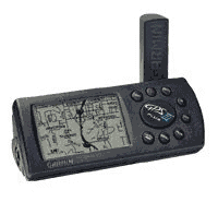
Using Garmin GPS for APRS
|
About GPS
The Global Positioning System (GPS) is a satellite-based radio location system operated by the US Depertment of Defence. 24 widely spaced satellites orbit the earth twice a day, continuously transmitting a timing signal, which allows any user with a low cost receiver to determine their Latitude and, Longitude to less than 10 metre accuracy.
How Does it Work?
Each GPS satellite carries an onboard atomic clock (Caesuim with Rubidium backup) which is used to generate a 10.23 MHz timing signal. This is transmitted using a carrier frequency of 1575.42 MHz (154 * 10.23) using 'spread spectrum' modulation.The receiver can calculate (by correlation) the arrival times of the signal from several satellites (up to 12 in the GPSIII+) simultaneously. By knowing the time and the positions of the satellites (from an on-board almanac) and their relative distances, the receiver can calculate its position - this is performed inside the GPS receiver approximately once every second and presented to the user on a Liquid Crystal Display (LCD).
The Garmin GPSIII+ shows this position as a pointer on an internally stored map, this is also output as position, speed and bearing in NMEA 0183 format to a computer port - the transmission of this information by packet radio is the basis for APRS
Top
Connecting to the Kenwood TH-D7
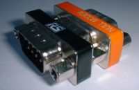
The easiest way to get started is to use the Garmin 'PC Data Transfer Cable'
and the optional 'Kenwood PG-4W', which are available commercially. However, as
both these cables are intended for PC communications, (they have 9-pin female connectors
and are wired to plug directly into the 'Com' port) a gender-changer and a null
modem adapter are required:
- Garmin 'PC Data Transfer Cable' - Maplin Order No KQ03D.
- Kenwood 'PG-4W' - Available from Waters and Stanton.
- Null Modem Adapter - RS Components, Part No 243-0374.
- Gender Changer - RS Components, Part No 218-239.
Custom Cables
If you have a Garmin GPS III+, you can make a cable for portable operation with a Garmin connector at one end and a 2.5mm stereo jack at the other - the main problem being the availability of the Garmin four-pole connector. This is not possible for the Garmin GPS 12, being an 8 volt unit, it has an additional dummy pin to prevent 12 Volts being applied.These are either available as a Garmin branded 'Power / Data Cable', complete with a flying lead from Maplin Electronics (Order Number 'KQ06G'), to which a 2.5mm stereo jack can be soldered. Alternatively, a 'cloned' Garmin connector can be obtained over the internet from www.pfranc.com and soldered to the supplied Kenwood cable.
Top
Press '
Enabling Communications
Garmin GPS 12
Press the 'PAGE' key repeatedly, until the main menu appears. Then using the rocker,
cursor down to 'SETUP MENU' and then press 'ENTER'. From this, select the
'INTERFACE' menu item and the following screen will appear.ENTER' to select 'NMEA/NMEA'. You should also select the protocol
version 'NMEA 0183 2.0' and the baud rate '4800 baud' you require.Garmin GPSIII+
From whatever GPS III+ screen is being displayed, press 'MENU' twice.
Then using the rocker, cursor down to 'SETUP' and then press 'ENTER'.
From the 'SETUP' menu, use the rocker to cursor along to 'Interface'
finally, cursor down and select 'NMEA'.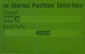
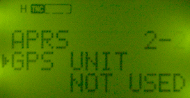
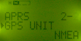
Kenwood TH-D7
Press the 'MENU' key, and then press '2' and '2' again.
The TH-D7 will display the following screen (left).
|
|
>' on the rocker and then the '^' to select
'NMEA', as shown right. Press the '>' to save the changes
and again 'MENU' to quit.
When communication is successful, the TH-D7 will bleep once, pressing the 'POS'
key on the TH-D7 will display the current position - the delimiters (degree and decimal
point) will flash. Once communications have been enabled, you are then ready to use the
TH-D7 for APRS. If the TNC is not already enabled, press 'TNC'
(the symbol shown on the displays above will illuminate). Finally, press 'BCON'
to enable your APRS beacon.
Top
Automatic Waypoint Entry
When connected to the Kenwood TH-D7 hand-held, the Garmin GPS 12
and Garmin GPS III+ support the automatic entry of APRS position data onto
their displays. The NMEA string '$GPWPL' is output by the Kenwood TH-D7 -
as shown in the examples below:
      $GPWPL,5346.17,N,00030.15,W,M1BLR *5C

      $GPWPL,5342.91,N,00027.05,W,N TOWE*36

      $GPWPL,5344.03,N,00025.68,W,G0VRM*6B
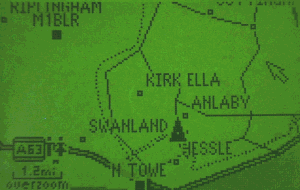
Incoming positions from the Kenwood TH-D7 are marked as a 'WAYPOINT'.
Although the APRS symbols may appear similar to those of the GPS III+, they
are not transferred. (The numbers following the '*' at the end
of NMEA strings are checksums.)
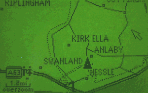
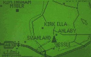
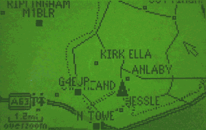
Example GPS III+ Displays
On first screen, no waypoints are displayed. Upon receiving the APRS packet from M1BLR, the position is plotted as a 'WAYPOINT' in the top left hand corner of the screen.
 |
|
 |
|
Top
Differential GPS (DGPS)
The intentional degradation of civilian GPS by the US Department of Defence, known as
Selective Availability, was turned off at Midnight on the
1st May 2000. Prior to this date, the accuracy of civilian GPS was reduced to
approximately 100m 2D RMS.
A pseudo-random error was introduced into the timing signals transmitted from each satellite, military users (and those authorised by the US Department of Defence) were able to remove the these effects by using an additional unit, attached to the GPS receiver that removed the error.
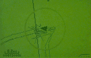
These effects were observable by zooming in the map display to the smallest scale. The position of a stationary GPS would then 'wander' around the screen. An example of this is shown in the screenshot below (taken over a 30 minute period), where the changes in position can be seen.
What is Differential GPS
Differential GPS was devised as a method for civilian users to increase their GPS accuracy, by removing the effects of Selective Availability. It works by measuring the errors from each satellite and calculating corrections, which are transmitted from a fixed ground station in a format known as 'RTCM 104'.The corrections are fed into the GPS and applied to the position calculations - using this method, an accuracy of up to 1m 2D RMS can be acheived. Differential GPS is still useful to those requiring such accuracy, as it removes naturally induced atmospheric effects.
Top
Obtaining DGPS Information
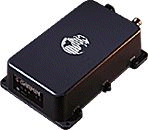
DGPS data is available to marine users from LF beacon transmitters. A Beacon Receiver
such as the Garmin GBR-21 is required.
The US Coast Guard operates a network of over 50 transmitters. Similarly in the UK, Trinity House operates a network of lighthouse based beacons:
A commercial (subscription based) implementation of Differential GPS in the UK uses the RDS data channel of the broadcast station 'Classic FM', this is used for an Automatic Vehicle Location application - probably similar to APRS!
ALRS Station Freq (kHz) 0005 St Catherines Point 293.5 0016 Lizard 284.0 0075 Butt of Lewis 294.0 0026 Nash Point 299.0 0178 Mizzen Head 300.5 0119 Flamborough Head 302.5 0086 Sumborough Head 304.0 0034 Point Lynas 305.0 0141 North Foreland 310.5 0097 Girdle Ness 311.0 0203 Loop Head 312.0 0197 Tory Island 313.5
A Differential GPS 'Reference Station Interface Board' kit is available from TAPR. However, the Motorola GPS module used in this kit has been discontinued.